
Contents
- In-depth understanding of physical phenomena
- Development of analysis methods for atmospheric circulation
In-depth understanding of physical phenomena
On the global scale, AGCMs (Atmospheric General Circulation Models), Regional Climate Models (RCMs), CTMs (Chemical Transport Models), and other models are used to numerically solve atmospheric motions. Within these models, the physical processes taking place in the atmosphere, ocean, cryosphere, and land surfaces are represented by mathematical equations (parameterizations) to further understand the Earth’s climate system.
The following are few examples of potential research in this field,
- Possible future climate
- Conduct numerical experiments by gradually
- increasing the greenhouse gases concentration (CO2, etc.) to evaluate the effects of the projected increase in anthropogenic greenhouse gas emissions, or
- increasing the sea surface temperature (SST) to analyze the climate in response to global warming.
- Evaluate existing GCM datasets (CMIP6, etc.) in assessing global or regional climate changes.
- Conduct numerical experiments by gradually
- Regional downscaling
- GCMs tend to have a horizontal resolution of around 1–3°. This resolution is too coarse and is not enough to represent details on the regional scale. Downscaling methods (dynamical and statistical) have been developed to address this gap. RCMs (e.g. NHRCM) driven by GCM output can be utilized to dynamically downscale and produce more detailed information about the regional climate. This information can also be used for impact assessment studies (flooding, drought, and other extreme events).
- Influence of ocean circulation and land surface on atmospheric circulation
- Simulations where global terrain is removed (aquaplanet experiment) can be performed to further understand the heat transport between the ocean and the atmosphere without topographic restrictions.
- Formation, movement, and dissipation of cold air mass
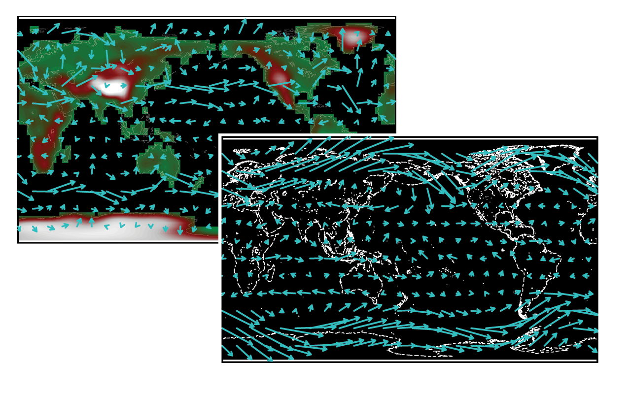
- During the boreal winter, the East Asian winter monsoon (EAWM) is one of the most active circulations in the Northern Hemisphere. As EAWM takes place, it leads to a strong southward flow of cold and dry air towards East Asia that occasionally reaches the Southeast Asian region. In our laboratory, the development and evolution from formation to dissipation of the cold air mass is studied, such as distinguishing the flow pathways.
Further reading:
Abdillah, M. R., Kanno, Y., Iwasaki, T., & Matsumoto, J. (2021). Cold surge pathways in East Asia and their tropical impacts. Journal of Climate, 34(1), 157-170.
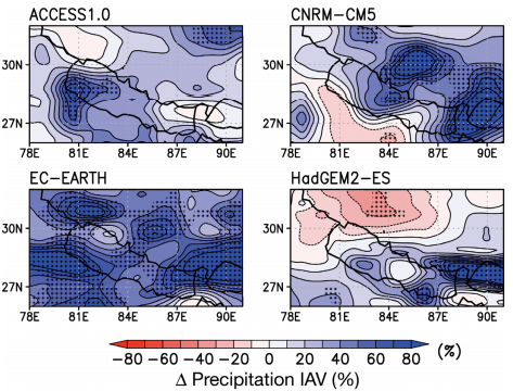
Kadel, I., Yamazaki, T., Iwasaki, T., & Abdillah, M. R. (2018). Projection of future monsoon precipitation over the central Himalayas by CMIP5 models under warming scenarios. Climate Research, 75(1), 1-21.
Sasai, T., Kawase, H., Kanno, Y., Yamaguchi, J., Sugimoto, S., Yamazaki, T., ... & Iwasaki, T. (2019). Future projection of extreme heavy snowfall events with a 5‐km large ensemble regional climate simulation. Journal of Geophysical Research: Atmospheres, 124(24), 13975-13990.
Development of analysis methods for atmospheric circulation
Within our laboratory, programs are developed to be used as tools in analyzing the general circulation of the atmosphere (large-scale atmospheric flow). These programs are useful for analyzing certain phenomena (e.g., distribution of greenhouse gases), interannual climate variability, evaluation of model performance, etc.
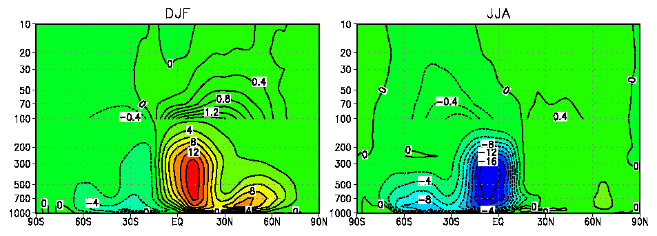
One of the methods developed in our laboratory is the Mass-weighted Isentropic zonal Means (MIM) diagnostic program. The MIM analysis program is capable of deriving mean-meridional circulation, wave-mean flow interactions, and energy conversion rates from conventional grid meteorological data (e.g., reanalysis data).
Further reading:
Iwasaki, T., Shoji, T., Kanno, Y., Sawada, M., Ujiie, M., & Takaya, K. (2014). Isentropic analysis of polar cold airmass streams in the Northern Hemispheric winter. Journal of the Atmospheric Sciences, 71(6), 2230-2243.
Liu, Q., Chen, G., Wang, L., Kanno, Y., & Iwasaki, T. (2021). Southward cold airmass flux associated with the East Asian winter monsoon: diversity and impacts. Journal of Climate, 34(8), 3239-3254.